
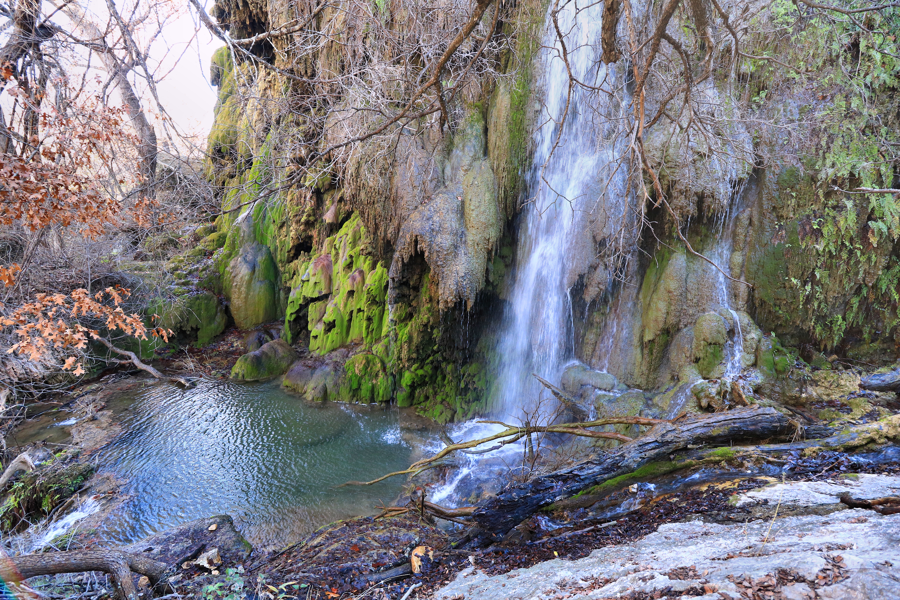
There’s a moment on the Gorman Falls Trail when you hear the water before you see it. Then you come around and there it is: a spring-fed waterfall pouring down a wall of green, mossy rock in the middle of Central Texas limestone country. It’s one of those views that makes a three-mile hike feel like a much bigger trip.
And that’s exactly where people get in trouble. They see “three miles round trip” and figure it’s a neighborhood stroll. It isn’t. Texas Parks & Wildlife rates the Gorman Falls Trail difficult. It flags rough rock and very little shade, and it warns about a steep, slippery descent near the water. The waterfall is unforgettable. So is the trail, if you show up unprepared.
This is the practical stuff: how far you’re really walking, how to pick your day, how much time to budget, and what to do when conditions don’t cooperate. Colorado Bend State Park is rugged on purpose. That’s a big part of why people love it.
Know the trail before you drive
According to TPWD’s official trail page, the Gorman Falls Trail is 1.5 miles one way, so roughly three miles out and back. The park tells you to plan for rough terrain. Its trail table lists about 1.5 hours, but a first-time visitor moving carefully will usually need more than that. Add in photos, water breaks, the heat, double-checking the route, and a slower climb back uphill, and the clock moves.
The toughest stretch for most people is right near the falls. The slope gets steeper and the footing can be slick. Wear hiking shoes with real tread, keep a hand free for balance, and slow down before the ground changes, not after. If someone in your group isn’t comfortable on loose rock or uneven footing, turning around is a perfectly good call. Nobody needs to force that last descent.
When you get there, stay off the delicate formations and don’t treat the mossy rock like a playground. Those features took a long time to form, and they depend on water and plant life to stay that way. Sticking to permitted paths keeps the falls looking like that for the next group.
Pick the right day, not just the prettiest forecast
Rain changes more than your photos. Colorado Bend warns that its entrance road can flood after heavy rain. So a clear, sunny afternoon doesn’t help you much if storms the day before washed out the road or the trail. Before you leave, check the park’s official alerts, the forecast and the condition of the access road. If you’re not sure, call the park and adjust.
Heat is the other big factor. The trail doesn’t offer much shade, so a nice temperature in town can feel a lot hotter out on exposed rock. Start early, bring more water than you think you need, and agree on a turnaround time before you set out. On a warm day, going slower is smarter than trying to beat the posted time.
Last thing: this is a popular park, and it can fill up. TPWD recommends reserving a day pass in advance. Buying a pass and checking trail conditions are two separate jobs. Neither one guarantees you safe access to the falls after a storm.
An honest three-to-four-hour plan
Start by confirming your reservation and checking in the way the park asks. Look over the trail map before you leave the car and know your route, any closures, and where the junctions are on the way back. Block out a generous chunk of time instead of squeezing the waterfall between two other plans. If your group is new to rocky trails, leave extra daylight and take a water break before the downhill section.
At the falls, enjoy the view from the permitted spots. Don’t climb onto wet rock chasing a better angle that probably isn’t there. Take a breather, eat something, and head back while everyone still has gas in the tank. The climb out almost always feels harder than the walk in, especially once the sun gets higher.
When you’re back at the car, drink some water and take stock before deciding on anything else. If you’ve still got energy for another trail, check the official map and current conditions instead of linking routes together from memory. Colorado Bend has plenty of trails, but Gorman Falls is a full day’s adventure on its own.
What about Spicewood Springs or the caves?
The park also shows off Spicewood Springs, the Colorado River and guided cave trips. They’re all great reasons to come back, but they shouldn’t automatically get piled onto your first Gorman Falls day. TPWD describes the 1.3-mile Spicewood Springs Trail as moderate to difficult, with creek crossings, and the cave tours have their own reservation requirements. If you want to pair them up, understand the terrain and how long each one takes before you commit.
Families with small kids, people who prefer easier walks, and anyone shaky on steep, slick ground may have a better day doing something else in the park. There’s no rule that says the most photographed trail has to be your trail.
A packing list you’ll actually use
Start with shoes that grip limestone and rocky ground. Bring enough water for the whole out-and-back plus a reserve for the weather. Add a brimmed hat, sunscreen, trail snacks, a small first-aid kit, a fully charged phone and a downloaded trail map. Put it all in a light pack. You don’t want loose stuff in your hands on the way down.
Tell someone your route and when you expect to be back. Have a plan for what you’ll do if the weather changes or someone in the group needs to stop. Trekking poles help some hikers on the rough stretches, but they don’t replace watching your feet, and you may want your hands free near the tricky spots.
Photograph the falls honestly
Every Gorman Falls photo you’ve seen shows what the waterfall can look like, not how much water will be flowing or what the trail will be like on your visit. Flow, light, vegetation and restrictions all change. When you post your pictures, label the place accurately. Don’t call it a swimming hole, and don’t encourage anyone to climb on the sensitive rock. If you’re using an older photo to plan, note the date so people know it’s not a live view.
Entry costs and practical checkpoints
As of our research, the official Colorado Bend page lists a $5 adult day-use fee, free entry for kids 12 and under, and standard park hours of 6 a.m. to 10 p.m. It also warns about entrance-road flooding and capacity limits. Check those details again when you reserve, since prices and hours can change. And late park hours aren’t a reason to start a rough hike in the evening.
The official Colorado Bend trail map has the final word on where trails go. Apps are great for planning, but once you’re out there, spotty service and unofficial route descriptions don’t outrank the signs or what a ranger tells you.
The Thunderfoot take
Gorman Falls rewards people who understand one simple equation: short mileage plus rough footing still adds up to a hard trail. Reserve your entry, check the weather and the road, start early, and carry enough water to move comfortably. Let the falls be the reward for a well-planned hike, not the reason you rushed a slick descent.
Fall is the sweet spot for this one, when the mornings are cool and the rock isn’t baking. Book your day pass, set your alarm and go see one of the best waterfalls in Texas the right way.
Editorial source check: Texas Parks & Wildlife Department, October 26, 2026. Confirm the latest park alerts, trail status and road conditions before travel.
Sources and verification
– https://tpwd.texas.gov/state-parks/colorado-bend – https://tpwd.texas.gov/state-parks/colorado-bend/trails-info